Virgin River Gorge Scenic Drive: I-15 Through Arizona
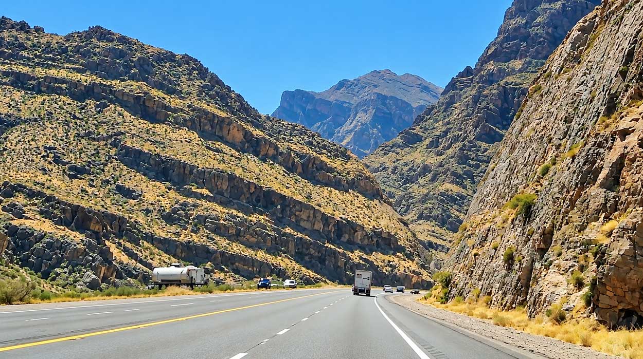
We were driving from Utah toward Las Vegas on Interstate 15 when the mountains began closing in around the highway. Massive rock walls rose beside the road, and each curve seemed to take us deeper into the canyon.
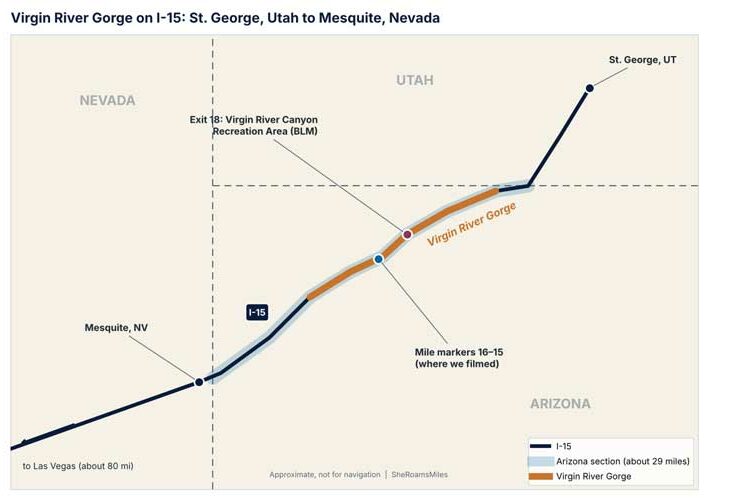
It was one leg of a family road trip from Texas through Arizona and Utah to the California border. Around Arizona mile markers 16 and 15, I recorded the winding interstate, the steep cliffs and the exposed rock layers towering above the traffic.
We drove straight through without stopping, and the views from the highway were enough. Afterward, I read up on how engineers built a four-lane interstate through the canyon.
If you’re driving I-15 between St. George and Las Vegas, here’s what to expect, how long it takes, where to stop and how this highway was built.
What's In This Article?
Disclaimer: This post contains affiliate links. They don’t cost you anything, but they help keep SheRoamsMiles running.
| Planning Detail | What to Know |
|---|---|
| Location | Northwestern Arizona, between Utah and Nevada |
| Highway | Interstate 15 |
| Arizona Distance | About 29 miles |
| Driving Time | About 25–35 minutes without stops |
| Scenic Stop | Virgin River Canyon Recreation Area, Exit 18 |
| Highway Fee | Free |
| Recreation Area Day-Use Fee | $2 per vehicle |
| Best Time | Daylight, for canyon views |
Where Is the Virgin River Gorge?
The Virgin River Gorge is in the Arizona Strip, the remote region of northwestern Arizona north of the Colorado River.
Interstate 15 crosses this corner of Arizona between St. George, Utah, and Mesquite, Nevada. It’s part of the main highway connecting Salt Lake City, Las Vegas and Southern California, and Arizona’s short stretch of it mainly carries travelers between neighboring states.
Driving Through the Virgin River Gorge on I-15
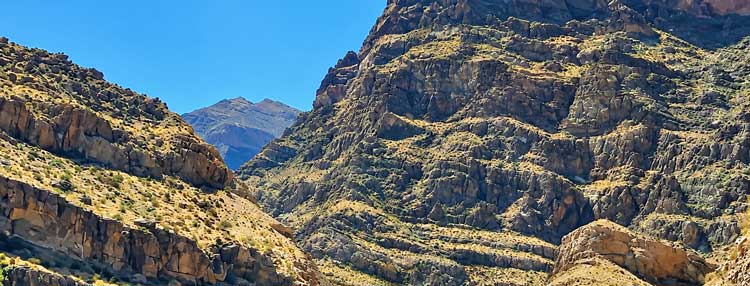
The canyon narrows as the highway winds between the mountains. Enormous rock faces rise above the traffic. Some slopes are covered in loose stone and sparse desert plants, and others are nearly vertical, with layers of limestone tilted and folded over time.
The road curves around the mountains, opening toward distant desert peaks before entering another narrow passage.
Our Drive Near Mile Markers 16 and 15
One of the most impressive stretches in our footage was between mile markers 16 and 15, heading southbound toward Nevada.
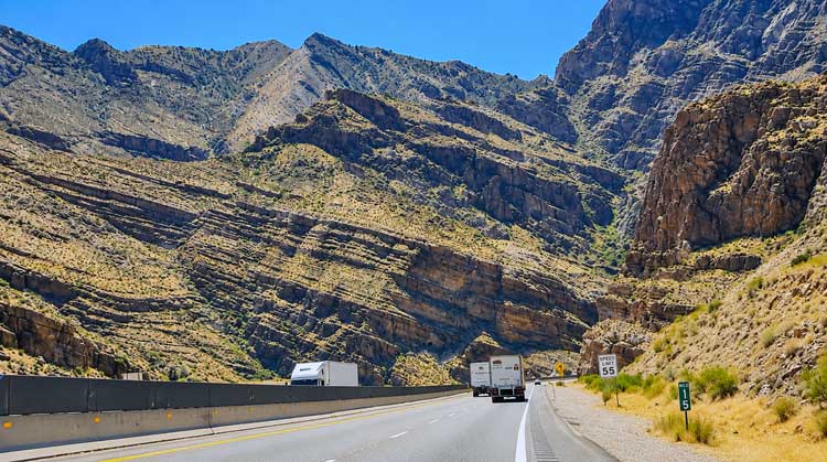
The highway bends between steep canyon walls, and what caught my attention was how close the mountains seemed to the road. Trucks and cars looked small against the cliffs.
Watch Our Drive Through the Virgin River Gorge
The Road That Shouldn’t Exist | I-15 Through Arizona’s Virgin River Gorge
Our six-minute video follows the highway through the canyon, with the winding road, steep rock walls and river corridor.
How Long Does It Take to Drive Through the Virgin River Gorge?
The Arizona section usually takes about 25–35 minutes without stops or delays. If you’re coming from St. George, the route is:
St. George, Utah → Virgin River Gorge, Arizona → Mesquite, Nevada → Las Vegas
If you want to stop and explore, add 30–60 minutes for the recreation area, or more for a longer hike.
Where Can You Stop Along the Virgin River Gorge?
The main stop is the Virgin River Canyon Recreation Area, managed by the Bureau of Land Management. It’s at Cedar Pocket Exit 18, about 20 miles southwest of St. George and 20 miles northeast of Mesquite.
We didn’t stop, but it’s the place to see the canyon outside your car. It has parking, drinking water, flush toilets, picnic areas and hiking trails.
Short Hikes and Viewpoints
| Trail | Distance | What to Expect |
|---|---|---|
| Canyon Overlook Trail | 0.4 mile | Paved, accessible trail to a scenic overlook |
| River Trail | 0.1 mile | Short walk toward the Virgin River |
| Ridgeline Loop | 1.1 miles | Steep route with elevated canyon views |
| Narrows Hike | 1.4 miles | Steep trail through Joshua trees toward limestone narrows |
For a quick stop, the paved Canyon Overlook Trail is the easiest. The River Trail is another short walk from the lower parking area, while the Ridgeline Loop and Narrows hike are more demanding.
The $2 day-use fee is waived with a qualifying America the Beautiful pass displayed in the vehicle. Check the official Virgin River Canyon Recreation Area page for current fees, facilities and trails.
Can You Stop Along I-15 to Take Pictures?
Use designated exits and parking areas. The highway has sweeping curves, steep canyon walls, heavy truck traffic and limited shoulders in places.
If you’re driving, keep your eyes on the road and let a passenger or a securely mounted camera capture the scenery.
Why Was I-15 Through the Virgin River Gorge So Difficult to Build?
Before the interstate, travelers followed US Route 91 over Utah Hill, a winding mountain route that was especially hard on large trucks. In the 1960s, construction began on a more direct highway through the Virgin River Gorge. It took about nine years and became one of the toughest rural interstate jobs of its era.
Building a Highway Through Nearly Impassable Terrain
Just moving workers and equipment through the canyon was hard. Crews blasted through steep rock faces, built bridges and created access routes along the river.
According to the Arizona Department of Transportation, engineers rappelled down rock faces about 400 feet high to place explosive charges. The project required seven bridges and extensive excavation, and the Virgin River had to be redirected in 12 places.
The Flood Warning System Made From a Barrel
Flash floods were one of the biggest dangers for construction crews, since stormwater could rush through the narrow canyon and threaten workers and equipment in the riverbed.
For an early warning, crews installed a metal barrel upstream. When rising water lifted the barrel, it tripped a switch that warned workers downstream, sometimes giving them as little as 90 minutes to evacuate.
Workers also faced extreme summer heat, winter ice and constant river crossings. Construction vehicles crossed the water so often that some pickup trucks needed new brakes about every six weeks.
When Did the Virgin River Gorge Highway Open?
The highway was dedicated on December 14, 1973. Arizona spent more than $48 million on its 29-mile section and seven bridges, about $1.63 million per mile, making it the most expensive rural interstate project completed in the United States at the time [verify: overall, or per mile]. The new route shortened the old journey by about 11 miles.
Source: Arizona Department of Transportation: Building the Virgin River Gorge Highway
How Was the Virgin River Gorge Formed?
The Virgin River carved the gorge over millions of years. It flows from southern Utah near Zion National Park, southwest toward Lake Mead.
The Bureau of Land Management reports that the river drops an average of about 70 feet per mile through the gorge. That steep gradient, combined with uplift of the surrounding landscape, let the river cut through layers of sandstone and limestone. From I-15, you can see rock layers that have been tilted, folded and eroded.
Is the Virgin River Gorge Worth a Detour?
If you’re already driving between St. George and Las Vegas, yes. It’s right on I-15, and the best scenery is visible from the highway.
As a separate trip, it depends on how much you enjoy scenic drives and whether you’ll stop at the recreation area. It’s an easy add to a longer Southwest road trip, like ours from Texas.
Flying into Las Vegas or St. George to start a road trip? Compare rental cars for your dates → [add car rental affiliate link]
Where to Stay Near the Virgin River Gorge
If you’re breaking up the drive, St. George and Mesquite are the closest places to stay, each about 20 miles from the recreation area at Exit 18.
Find hotels in St. George or Mesquite →
Is the Drive Good for Families With Young Kids?
Yes. You can enjoy it entirely from the car, so it fits easily into a family road trip.
For a break, the paved Canyon Overlook Trail is a short walk. Check the temperature before getting out, since the desert gets extremely hot in summer.
Tips for Driving Through the Virgin River Gorge
- Drive during daylight. The canyon walls and rock formations are the main attraction.
- Check road conditions before you leave. Construction, crashes and weather can affect travel through this narrow corridor.
- Expect truck traffic. I-15 is a major interstate route.
- Watch the weather. Heavy rain can cause flash flooding, and winter conditions can affect the highway.
- Get gas in St. George or Mesquite. Services are limited inside the gorge.
- Bring water if you plan to walk or hike.
For live highway information, check Arizona 511.
Virgin River Gorge FAQs
Is the Virgin River Gorge in Arizona or Utah?
The Virgin River Gorge section of Interstate 15 is in northwestern Arizona, between Utah and Nevada. The Virgin River itself also flows through Utah and Nevada.
Is the Virgin River Gorge on I-40?
No. It’s on Interstate 15. Interstate 40 runs farther south through Arizona, through Kingman and Flagstaff.
Do You Have to Pay to Drive Through the Virgin River Gorge?
No. Driving I-15 through the gorge is free. The BLM recreation area charges a separate day-use fee.
Can You Drive an RV Through the Virgin River Gorge?
Yes. I-15 is a major interstate used by commercial trucks and RVs. Pay attention to grades, curves, wind and heavy truck traffic.
Final Thoughts
The Virgin River Gorge was one of the most striking stretches of highway on our drive from Utah toward Las Vegas. If your Southwest road trip takes you along I-15, plan to cross it in daylight, and take Exit 18 if you want a closer look.